Our “Cookbook” provides you with basic information, instructions and tips: similar to a classic cookbook. In the same analogy, the cookbook has no “red thread”, so it is only suitable for reading through to a limited extent.
Is something missing or wrong? Please let us know via the contact form.
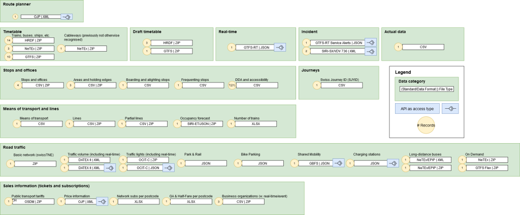
All pages of the cookbook can be found via the search function. The overview below illustrates what you can search for.
Overview
Who we are and where our data comes from
The Open Data Platform Mobility Switzerland (ODMCH) is operated by the System Tasks Customer Information Plus team “SKI+” (German only) with partners/suppliers.
The work of SKI+ is carried out on behalf of the Federal Office of Transport (FOT) and is financed by the Rail Infrastructure Fund (RIF). The work serves as preparation for the NADIM (National Data Networking Infrastructure Mobility). With NADIM, the federal government wants to enable efficient, climate-friendly, multimodal, inclusive and safe mobility and ensure international connectivity with the EU. In addition to ODMCH, the SKI+ team (German only) is also responsible for the Open Journey Planner and is working on the design of the NADIM services.
Against the background of the implementation of the future NADIM, SKI+ is meanwhile publishing uniform (interface) standards (German only) on behalf of the FOT in order to make a positive contribution to the harmonisation of the system landscape in public transport.
You can find out more about the connections and the relevant peripheral systems in our Big Picture.
How you can access our services & data
You can access our services via the programming interface (API).
You can access our data in two ways with equivalent results:
- Via a download (→ structured or unstructured)
- Via the Comprehensive Knowledge Archive Network (CKAN) programming interface (CKAN-API → howto)
Graphical overview of our services & data
The following graphic provides an overview of the data provided, its origins and access options:
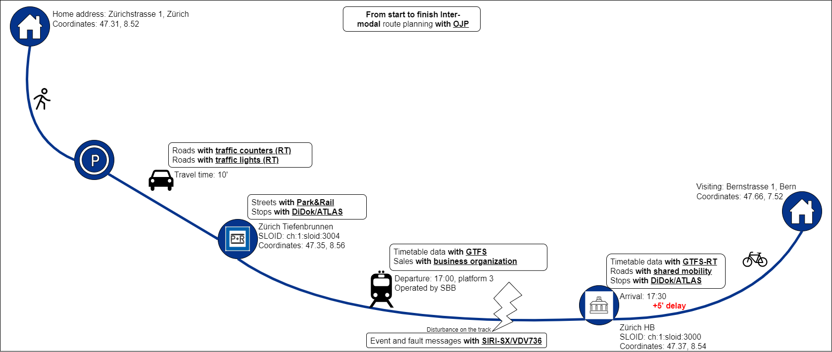
The following illustration of a travel chain calculated with the OJP shows what can be done with this data:
Further background information on our services & data
Route planner
You can access two route planners via our programming interface (API).
| The most important interfaces |
Timetable, real-time, event and actual data
A timetable provides information on which line runs with which means of transport, with which characteristics, when and along which places, and much more. For example, that the IC5 train (means of transport and line) on which bicycles are allowed (property) departs every Monday at 12:00 (when) from the Zurich main station stop (which location).
A draft timetable is published every year before the finalised (annual) timetable. The source system for all timetables (and drafts) is called INFO+ (German only).
We offer you timetable data in 3 data formats:
- General Transit Feed Specification (GTFS)
- Hafas Raw Data Format (HRDF)
- Network Timetable Exchange (NeTEx)
Note: The timetable data of certain cable cars and chairlifts are not covered by the current data collection structures.
Plans change! That’s why you need the real-time and event data for the timetables. Matching is required to bring the planned and real-time data together. We are currently publishing the data format for the real-time data:
- GTFS-Realtime (GTFS-RT) Trip Updates
- SIRI-Estimate Timetable (SIRI-ET)
- SIRI-Planned Timetable (SIRI-PT)
At the same time, we provide the daily formation data. These extend up to 30 days into the future, but only with incomplete data. The accuracy of the data increases towards the day of the query (“Today”).
We provide the following for event data such as faults:
In addition to the real-time and event data, we also publish the “actual data“. These are the journeys actually made or forecast in relation to the planned journeys (timetable) on the previous day. In other words: now is real time, and later is “actual”. It should be noted that certain threshold values for communication apply to delay forecasts in Swiss public transport.
The most important data and interfaces
|
Stops, offices, journey
- Journey in the timetable is carried out along certain stops and has a unique journey ID (new Swiss standard: Swiss Journey ID, concept see öv-info.ch, German only).
- A stop, also known as an operating point, is a place where passengers have official access to public transport.
- Service centre extends the stops to include locations that have an indirect function in public transport, e.g. travel agencies.
The source system for all offices (and therefore also stops) is called ATLAS.
| The most important data |
Means of transport and lines
We currently offer data on various modes of transport, e.g. trains, buses, (sharing) cars, (sharing) bicycles. Where possible, we are expanding the available data sets to include other means of transport and providers of multimodal mobility services related to public transport.
In public transport, the primary means of transport are trains and buses. These usually have a designation, e.g. “S5”. The so-called line or line designation helps public transport users to identify the means of transport to be used. However, the concept of the line goes much further than this “commercial” view. You can read about this in the Swiss line directory and in the sources linked in the article.
For some rail-bound transport companies, we are able to provide an occupancy forecast, i.e. how full the train is likely to be.
In addition, in cooperation with some rail network infrastructure managers or railway undertakings (RUs), we can also indicate the number of trains on the sections of the railway network, i.e. the frequency of the routes between certain stops.
| The most important data |
Road traffic
Our data goes beyond public transport and also includes road traffic: thanks to close cooperation with the Federal Office of Topography (swisstopo), the Federal Roads Office (FEDRO) and the Swiss Federal Office of Energy (SFOE), among others.
- swisstopo provides the basic network for all transport operations within the Swiss transportation network (swissTNE).
- FEDRO provides data on traffic volumes and traffic lights. IMPORTANT: The special General Terms and Conditions of FEDRO apply to this data.
- The SFOE provides data on the charging stations at www.ich-tanke-strom.ch when your electric car needs refuelling. You can find the documentation on Github.
As soon as you want to switch back to public transport, the Park & Rail and bike parking spaces will help you.
If you don’t have your own bike or car, we refer you to the locations and availability of shared mobility offers from the SFOE. Or you can take the long-distance bus.
We are also currently working on modelling the vehicle pooling offers in Switzerland and then making this data available. Other terms for vehicle pooling are car pooling, ride sharing, carpooling, carpooling or car hire (rarely also car sharing).
On-demand transport, on the other hand, has already been modelled, i.e. services where you can use a journey “on demand” and possibly share the journey with other passengers. One example is the door-to-door service offered by PubliCar in Appenzell, which complements the existing public transport system. We provide the data as NeTEx (German only) and GTFS.
The most important data and interfaces (real time)
|
Sales information (tickets and subscriptions)
The basis for sales is the business organisations involved. A business organisation usually corresponds to a transport company. Some of the business organisations provide us with their real-time data and/or event data.
The alliances of these companies (e.g. the Alliance SwissPass in public transport, German only) provide travelcards, such as the GA travelcard or Half-Fare travelcard, in Switzerland. We also provide data for analyses in this area.
- For tariff information, we provide the Open Sales and Distribution Model (OSDM) (German only) as a static “offline” file.
- Dynamic price information can be requested via the OJPFare interfaces (link to data set, cookbook in preparation).
| The most important data and interfaces |
Do you have any more questions?
Then our FAQ will certainly help you. If you can’t find the right answer there, you can reach us via the contact form.
Further information
- Examples and inspiration on how to use the data provided:
- Standards of the System Tasks Customer Information (SKI) (German only), the superordinate organisational structure of SKI+, which also operates on behalf of the Federal Office of Transport.
- You can find a comprehensive overview of various helpful tools (APIs, apps, data, etc.) for processing traffic data at https://github.com/CUTR-at-USF/awesome-transit.
Mini sitemap
Route planner:
- via Open Journey Planner (OJP). Further links:
- OJP – Open Journey Planner
- API Explorer
- OJP Known Issues (in progress, link to follow)
- OJP – Open Journey Planner: Non-discrimination (in progress, link to follow)
- OJP Sysrequest
Timetable data:
- Overview article:
- Real-time data in General Transit Feed Specification (GTFS, see below) Realtime (GTFSR) format
- tatic data in two different formats:
- Static data in the new NeTEx format (Alpha):
- here we refer to the data page
:Timetable 2022 (NeTEx)
- here we refer to the data page
- The draft timetable:
- here we refer to the data page timetable design groups
- Occupancy forecast data (Occupancy Forecasts):
Stopping and service points:
- In the Comprehensive Knowledge Archive Network (CKAN) format:
- CKAN-API
- Important: please note that CSV data can generally also be offered via CKAN.
- Static stops/service points
- Stops at stops:
- Accessibility:
- Here we refer to the data page: Data on the accessibility of public transport stops in Switzerland
- Here we refer to the data page: Data on the accessibility of public transport stops in Switzerland
- Passengers boarding and alighting per station:
- here we refer to the data page: Boarding and alighting
- Means of transport and tips:
Line directory:
Road traffic data:
- Static road traffic data:
- Real-time road traffic data (must be combined with the static data):
- Charging stations.
- To be found on www.ich-tanke-strom.ch with the corresponding Github
- Shared Mobility:
- Here we refer to the data page: Locations and availability of shared mobility offers
- Park & Rail:
- Bike parking (bicycle parking spaces)
Distribution:
- Business organisations:
- Business organisations
- GO Realtime (business organisations that provide real-time data)
- Network subscriptions per postcode:
- Here we refer to the data page: Number of combined subscriptions per postcode
- GAs and half-tax per postcode:
- Here we refer to the data page: General Abonnement and Half-Fare travelcard list
Shared Mobility:
- Information on Vehicle Pooling (aka. Car Pooling, Ride Sharing, Carpooling, Carpooling, or Car Service Organisation, (rarely also Car Sharing)):
- Vehicle Pooling (German only)
Operational & other:
- Driven or predicted journeys:
- Railway line network utilisation:
- Helpful tools:
- A comprehensive overview of various helpful tools (APIs, apps, data, etc.) for processing traffic data: https://github.com/CUTR-at-USF/awesome-transit

