Master data and metadata
We provide various master and metadata. On the one hand, information about the basic infrastructure components of the Swiss public transport system, i.e. lines (including partial lines), services, areas and stops. On the other hand, details about the means of transport, business organisations and large-capacity profiles for car trains.
A part of the data can be optained directly via the master data system atlas. (SBB-Login needed: https://developer.sbb.ch/apis/atlas/information)

Description
Master data and metadata contain a wide range of different types of information.
In Switzerland, the Customer Information System Tasks (SKI) is responsible for collecting, consolidating and publishing a wide variety of customer information master and metadata. It does this CENTRALLY for public transport throughout SWITZERLAND. For some of this data, SKI has the initiative ‘Swiss Identification for Public Transport’ (short: SID4PT). This includes:
- Lines and partial lines, e.g. the ‘S5’ line which runs between Zurich and Zug. With the SLNID, there is a unique identifier for each line and sub-line so that all objects can be uniquely identified across all customer information.
- Service Points, areas, stop boarding areas, e.g. a travel counter operated by a railway undertaking, but also specific stops such as ‘Bern, Bahnhof’ as well as stops and areas. They are uniquely identified by the Swiss Location ID (SLOID).
- Business organisations, e.g. ‘BLS’. The business organisations represent the organisational structure of transport companies according to billing and customer information characteristics. They are mapped by the Swiss Business Organisation (SBOID).
The team atlas also offers:
- Timetable field numbers: This data set contains all route tables in Switzerland. It contains the outward and return journey and the route table numbers in addition to the means of transport and the business organisation responsible (part of a transport company).
- Sectors and sector groups (to follow in June 2026): This data set contains all sectors and sector groups recorded in atlas. Each sector and sector group has a SLOID and is assigned to a stop. They can only be recorded at stops to which they assigned the means of transport to rail.
With regard to the stops, we also provide the FOT stop list available.
In addition, we provide information on the large-capacity profiles BLS, the Basic network of the Swiss transport network, the Lists of means of transport and notices (incl. Tarif codes), as well as the Service Directory of mobility services.
Thanks to close cooperation with the Federal Office of Topography (swisstopo), we also provide the basic network for all transports as part of the Transport Networks Switzerland (VnCH).
Services and data
We offer most data sets in three variants:
- ‘actual-date’: Data sets that are valid on the current day (today).
- ‘full’: all records for all validity periods (past and future).
- ‘timetable-years’: Data sets that apply to the current and upcoming timetable year.
Explanation of terms
| Term | Explanation |
|---|---|
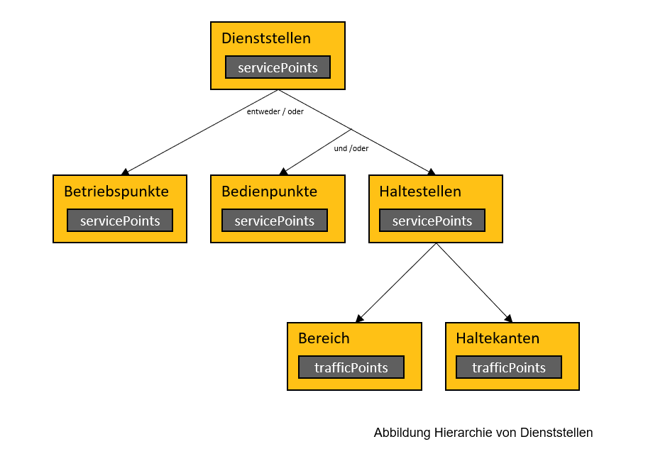
| Service Points | A collective term that describes all places that have a function in public transport, from stops to travel agencies, for example. Not all of them are relevant for publishing the timetable. See also picture below. |
| Operation Points – Service Points | Departments relevant to operations without a commercial mandate (e.g. branches, depots, …) |
| Freight Points – Service Points | Departments relevant to freight services for loading and unloading goods |
| Stop – Service Points | The term ‘stop’ is used differently. Opentransportdata.swiss refers to the place where passengers (passenger services) have official access to public transport. Thus, a stop represents the generic term for all modes of public transport. This means, for example, stations, boat docks or cableway stations. Every stop in Switzerland originates from the atlas application (see also here). This ensures that it is uniquely identified and given a unique name and that this name complies with the Geographical Names Ordinance. A stop is usually divided up more finely, e.g. into stops, sectors or platforms. However, it can also be combined with other stops in a higher level, e.g. meta stations or mobility points. |
| Stop Place – Service Points | Are the places where people can board a means of transport (e.g. platform) |
| Stop Area – Service Points | Enables several stops to be grouped (e.g. into platforms) or even areas. |
| Meta stop | Meta stops are various stops that belong together specifically for changing trains. A typical example is the station stop for local transport and the station itself. |
| Line | In public transport, the primary means of transport are trains and buses. These usually have a designation, e.g. ‘S5’. The line or line designation helps public transport users to identify the means of transport to be used. However, the concept of the line goes much further than this ‘commercial’ view (see further information on SLNID). |
| Sub-line | A route segment bundles journeys within a line according to operational or concession criteria. As with the lines, the concept is more complex and can be read in more detail in Further information on the SLNID. |
| Business organisation | Business organisations (business organisations) usually correspond to one transport company. However, there are also transport companies that comprise several business organisations. For example, if the company offers both rail and bus services. |
| Transport companies | The source for transport companies is the Directory of Transport Companies published by the Federal Office of Transport. The reference between the business organisation and the transport companies is maintained and published by SKI in the atlas system (see also here). |
Further links
SLNID
The identification of a line or part of a line is currently not clearly transmitted to the SKI systems by the transport companies.
SLOID
Stop areas and other stop objects are essential for providing customer information. However, there is no structured definition and unique identification of these objects.
SBOID
The current business organisation number is not a suitable identifier because these numbers are used multiple times and are therefore not unique (= no ID in the technical sense).